Walking and Photography in the Greek Islands
Maps of many of the Greek Islands are very poor compared with say, OS maps of the UK or the IGN maps of France. So, for many islands, is the level of detail on Google Earth. Some footpaths are very good, others are difficult to find and follow, few are shown on maps. Walk books are sometimes available and can be helpful but are usually purely descriptive. Therefore walking guides are being prepared which use a combination of photographs of key way-points and GPS referencing using the international default WGS84 as well as description.
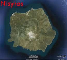
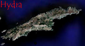
Descriptions of walks for three islands have been completed so far, on the Dodecanese islands of Symi and Nisyros and, using an older format without grid references, 3 walks on the Saronic island of Hydra.
More walks are in preparation on Symi and on Nisyros and will be added as time permits. |
|
 |
last updated
03 July 2009
|
| |
 |
|
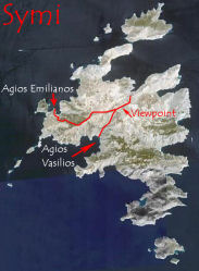
Symi is a small island with plenty of opportunity for walking on many paths and 'kalderimia'. Some of these are easy to find and follow, others are more challenging. A few are damaged by road construction.
Symi has the reputation for being the dryest and hottest of the Greek islands with obvious implications for carrying sufficient water |
Guides for 3 walks have been completed so far:
Walk 1 - to Viewpoint above Horio.
Walk 2 - to Agios Vasilios and Lapathos Beach
Walk 3 - to Agios Emilianos
Google Earth now shows Symi at fairly high resolution. Fly to Symi with the link below and zoom in to see these walks plotted from the edge of the built up area of Horio to the placemarked destinations. Zoom in to look at details of the paths on the ground. Activate and click placemarks for information.
Guides for another 5 walks are in preparation:
Walk 4 - to Nimborio and its basillica and caves
Walk 5 - to Nimborio and Agios Nikolaou Stenou
Walk 6 - to Paraskevi and the Nimborios Gorge
Walk 7 - to Zoodohou, Gria and Pedi
Walk 8 - to Agios Polemou and Nanou Bay |
 |
Fly to
|
 |
with Google Earth |
|
|
|
|
|
|
|